2011-09-30 - to Chesapeake City, NJ


Historic Chesapeake City from the water

A lighthouse in  Delaware Bay
 We set our alarm to head out early this morning.  Skipper Bobs guide suggested leaving two hours after low tide.  This meant an 'almost tolerable' 6:00am.   A few other boats anchored in the harbour also are avid Skipper Bob readers because there was a little bit of an anchorage parade going on at this early hour - a lot of red and green navigation lights moving through the dark anchorage.  The sun was soon to rise which was great.  It took about an hour to get through the uneventful Cape May Canal linking Cape May with the Delaware Bay.  There are limitations to this canal.  If your mast clearance is more than 56 feet...you have to go on the outside.  This was a much calmer alternative and we were glad that our mast is only 47 feet.   We didn't know what to expect on the Delaware Bay.  The winds were favourable as they weren't opposing the current.  We had a nice South/South-West wind which made for a very brisk sail.  With the current in our favour and the wind, we did between 9-11 knots the entire time.  There was still quite a bit of debris on the water which required a sharp and scanning eye at all times.  We arrived at the C+D Canal at the top of the Delaware Bay at 12:30pm. 
Another calm canal with lots of interesting bridges filled the next 2 hours of motoring.  We arrived at our destination, Chesapeake City, at 2:30pm.  We dropped anchor and jumped in the dinghy to explore this very old town full of gift shops and antique stores.  As we were coming back we met a lovely family from Quebec who were just anchoring on a boat called Larose des Vents.  They are a family of 5 and are also on their way south.  Finally, another boat heading our way! Connor ended up jumping onto their boat to play with their children.  Unfortunately, they were too good at their english to entice Connor to try out his french.  They had a great time, though!

2011-09-29 - to Cape May, NJ


The 'rage' coming into Cape May Inlet
 We left the dock 7am, heading for Cape May.  It was still a bit choppy out there, but we all did great.  Connor got his bed out again in the cockpit and snoozed for half of it.  We didn’t do school in the past few days.  The bouncing makes it very difficult to be inside.  We’ll have to hit it hard again once we get to the Chesapeake.  During the passage, we could see lightening in the distance.  We didn’t get hit with that but we did get about 3 hard rain squalls.  We were thankful for the radar as it could tell us what shape this rain system was and when we would get out of it.  They were all short lived (<5 min).   The highlight today was when we saw a WHALE!  I was at the helm and all of a sudden I saw a puff of water coming from the waters about 100 feet in front of the boat.  I thought I was seeing things but called Kerry and Connor out.  Kerry was out first and then the whale came up out of the surface and we could see the dorsal fin.  By the time Connor came out, the whale had moved away.  We kept searching and then saw another blow and then the tail come out of the water.  Very cool.  As we entered the Cape May Inlet we experienced a ‘rage’.  This occurs, I believe, when you have opposing wind and current.   The water was leaving the inlet and the wind was blowing against it.  This creates very large and chunky waves.  We just had to keep riding them and moving forward.   Our speed would go down to 0-2 knots as we rode the wave up and then speed up to 7 knots as we were coming down the wave.  Hi5 (and Kerry) handled this well.    We pulled in to gas dock and the currents inside there were crazy.  The man there said that the extreme tides were caused by the ‘Perigee’.   I had not heard that term before, but it has something to do with the moon phases.  We anchored east of the Coast Guard station and breathed another sigh of relief.  Throughout the day more and more sailboats were coming in.  We are finally seeing more boats heading south which is great.  These last few days are probably the biggest outside jumps that we need to do.  Tomorrow we head up the Cape May canal to the Delaware Bay and then through the C+D Canal (Chesapeake/Delaware Canal).  Then, we will slow it down a bit and try to enjoy the journey.

2011-09-28 - to Atlantic City, NJ

It was an early start today.  Not as early as the fleet of fishing boats leaving /clanging at 3am!  So, at 6:15 am, together with Ilira we headed out.  It was a very rocky day. The waves and chop were doing Connor and I in.  Connor ended up sleeping on and off in the cockpit.  He handled it well.  The plan was to go all of the way to Cape May, if the weather and seas were fine.  If not, we would head into Atlantic City.  We ended up making that call early.  There was no need to be out in that, if we didn’t have to.  Ilira, on the other hand, kept going to Cape May.   I don’t think that we could have done 6 more hours!  We pulled into Atlantic  City and pulled up to a dock and called it a night.

2011-09-27 - in Manasquan Inlet, NJ

We woke up bright and early this morning to sqeeeeze our way out of the Glimmer Glass bridge.  We went through it yesterday, and knew we could fit, but now it was high tide.  (Yesterday we came in on the low).  Would this change anything?...we would see.  With all fenders hanging...we managed to slip through.  Kerry kept Hi5 pointing straight and on the wall and I just stood there with my trusted boat hook to ensure that we didn’t get too close.  Once again we survived.  Whew.  As we left the bridge we noticed that the fog had really come in again.  It was so thick that I made it difficult for us to find the first gas dock that we just wanted to land on so that we could make a decision on what to do.  We decided very quickly that we would not proceed today and find a spot to stay for tonight. The gas attendant told us about some of the restaurants in the small cove near the entrance of Manasquan that allow boats on their docks if they eat there.  Perfect.  We headed over there, but we could barely see in front of the boat.  I went up to the bow to see if adding 30 feet would help.  It was very disorienting.  We landed at one of the restaurants.   Kerry, went up to check with them if it would ok to stay on the dock.  They didn’t mind…but, had a policy of 'overnighting'.   Once we got settled, we decided to take a bike ride over to the boardwalk amusement area.  We checked the internet and found out that they also had an aquarium.  It was a wonderful place.  They even had seals, penguins, alligators, sharks, etc.  Most of the animals were rescues.  The seals were found injured just out on the ocean close to the aquarium, and the alligators were pets, etc.   The boys really enjoyed it.   It was a great way to spend a very foggy day. 
On our way back we stopped in at a local bait and tackle shop and purchased our first rod and reel.  We then biked several blocks to another marine store that had the rod holder that fits on stainless steel bars.  When we arrived back at the boat another sailboat called, Ilira, was slowing down to inquire about the dock we were on.  We grabbed their lines and had a quick chat.  He told us of all the excitement he just had coming from New York.  It was almost identical to our ‘excitement’.  He was glad to be stopped.  We ended up going to another dock at a restaurant together and both he and Kerry chatted with the owner to see if we could stay on the dock with a meal.  It would be fine.  We cleaned up quickly and had a wonderful meal. 

2011-09-26 - to Manasquan Inlet, NJ

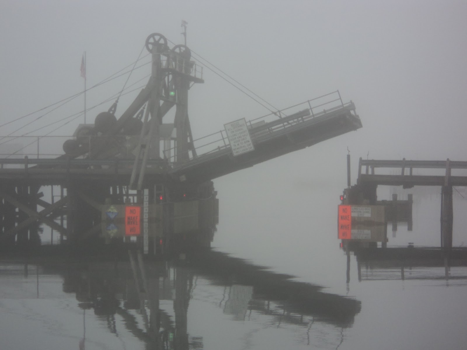
What a day.  Where do I begin?  We left the anchorage near the statue at 9am to catch the flush leaving the harbour.  We are close to the last bridge, the Varazanno-Narrows bridge.  All major ship traffic travels under the 4260 foot span bridge with a 228 foot clearance – it’s very impressive.  There were a few moments that took our breath away today – here is the first.  As were approaching the bridge, fog started to settle in a bit and what comes out of the fog was a monster freighter.  No problem, we are far away on the other side of the channel.  Just then we heard a loud, HOOONNNK.  It was the ship indicating something….now, what was does that mean again….hummm….oh, my – now we remember – it means that it is about to turn….towards us.  All in all we were fine.  It is just that we are so small  in the harbour compared to most of the other traffic.   The fog seemed to settle in more as we continued to leave. Our radar was spinning away looking for other ships.   We stuck to the outside of the channel  and plotted our course on the paper charts as well – just to be extra cautious.  Our charts, however, didn’t align well with respect to the bouy markers.  We had our GPS which is the ‘newest’ and should have the most up to date information….so, we stuck with that.  We would watch for channel markers as they slowly appeared into our vision.  They were right on track.  We plotted them and looked for the next.  The next nervous moment was when we heard another ‘HOOOONNK” – another ship is out there and about to turn.  We looked on the chart and determined that it was approaching the channel and would go right by us.  We didn’t even see it, but new it went by as the wake rocked our little boat.    Another ship appeared out of the fog, but we were in the straight park of the channel, no sweat.  As we approached the outermost part of the channel we breathed a sigh of relief – we would be heading south now and maintain 3 miles off of the shore line for Manasquan Inlet.  What could go wrong?  About ¾ of the way to Manasquan, I was inside with the kids when I the engines reved up and Kerry said something that I couldn’t quite make out…but, I wouldn’t be able to repeat it anyway I am sure if I did know what he said.  He tracked something on the radar that was coming at us quick.  Before he could really assess what it was it appeared out of the fog.  It was a large sport fish boat that was going at least 30 knots, tearing through the fog.   It went right behind us  and no harm….but, he should not have been travelling that fast.  We were heading in to the Inlet –phew – what a day.  You probably think that that was the last thing that would get our hearts pumping…..well, you are wrong.  To land in an anchorage that Skipper Bob had described we have to go under the Glimmer Glass Bridge.  This bridge, we now have read, was built in 1898 and has most of the original mechanisms used to open it.  The bridge operator explained that the max width in the bridge is 26 feet (we are 18) but when the bridge opens the max clearance under is 52 feet as it doesn’t open all of the way (we are 47 feet).  He said he would open it and we can make a decision.  Sailboats can make it through if they stick to the left side of the bridge…but with a catamaran our mast is in the centre of our boat which is over a couple of feet of a regular sailboat.  So, Kerry told the bridge operator that we’ll ‘take a run at it’…. Hummm.  Anyway, we approached the bridge.  We had fenders down, Kerry kept us close to the wall, I grabbed the boat hook to keep us as close as we could.  When I heard the operator say, ‘your good’ – that’s when I thought we could now breathe a sigh of relief.  Because what else could go wrong?   As we approached this very small anchorage there was one boat in the water that was submerged up to the roof. We would tell that it was on the bottom and that the water it was in wasn’t too deep.   We made a nervous but steady approach and managed to throw our hook down in about 5-6 feet of water and turned the engines off.  Whew!   Now we could relax.

2011-09-25 - to Statue of Liberty anchorage, NJ

 We woke up in New York ready to take on another day.  We headed for the subway to brave a trip to the south end of Manhattan to check out Battery Park, Statue of Liberty and the 9/11 Tribute.  Negotiating the system with a wheelchair proved to be a little more difficult than determining which train to take.  As with most subway systems, stairs and turnstiles are common.  We ended up taking him out and piecing it through bit by bit.  On the return trip we were told we could go out of the ‘emergency exit’ door…but the screeching alarm made us feel that we were in an evacuation.  There was a benefit run all around the 9\11 site that was called ‘Tunnels to Towers’.  It was a tribute to the fallen firefighters of 9/11, from what I gathered, and after there was a parade of firefighters complete with bagpipes.  It finished off with a live band singing the national anthem and other patriotic songs.  Lots of Cheering and clapping could be heard for hours.  We managed to find a local park to hang out and relax to enjoy the moment.  We jumped back on the subway and headed back to the boat.  We were planning our next move as we needed to make a decision whether to stay on the dock for another night…or anchor out.  Kerry checked the tide tables which show which way the flow will be going and what time.  We need to go with the tide as it can be about 2-3 knots.  If we are going against the flow….we would only be doing 3-4 knots.  It was determined that we had only 1 hour left to get off the dock, if we wanted to ‘go with the flow’.  We cast our lines (after checking under our boat for any trapped debris) and headed back on the Hudson.  The Hudson was rather quiet as it was Sunday which made it a little easier trip, albeit very rolly from the few passing boats.  We even buried our bow a bit.  Our destination was an anchorage near the Statue of Liberty.  It was listed in Skipper Bobs as a nice anchorage by the Liberty State Park.  It checked out completely – as it was exactly as described.   We dropped anchor and heated up a bit of supper.  Connor grabbed his harness and began swinging away under the watchful eye of Lady Liberty. 

"Guess what I lost today?"  "I am wiggling it with my tongue!"